In August 2017 a storm parked itself over Houston and would not leave. Hurricane Harvey dropped 60 inches of rain in places, the heaviest total from a tropical storm in United States records, and left about $125 billion in damage. Most Texans remember the water more than the wind. That memory holds the key to how these storms work. A hurricane is built in stages, each one feeding the next, and the final stage is almost always about water.
Follow the stages in order and the monster gets easier to understand. No single stage does it alone. All of them have to line up, hold, and grow.
Stage one: The five ingredients assemble over warm water
Every hurricane starts as a recipe that rarely comes together in full. Leave out one part and the storm fizzles. Bring all five together and the sky has what it needs to build an engine.
First, the ocean has to be warm, at or above 80 degrees Fahrenheit, and that warmth has to run deep, to roughly 150 feet. A thin warm skin is not enough. As a storm churns the sea, it pulls cooler water up from below. If the deep water is cold, the storm starves itself. If the warmth runs deep, the fuel lasts. The Gulf of Mexico in late summer often sits past 85 degrees, which is prime fuel close to the Texas coast.
Second, the air has to be moist through a thick layer of the atmosphere. Dry air sliding into a young storm chokes it. That is why outbreaks of dry, dusty air off the Sahara can quiet the Atlantic for days at a time.
Third, the winds have to be calm in a specific way. Wind shear, the change in wind speed and direction with height, has to be low. Strong shear tips a storm over and tears its top away from its base. Low shear lets the storm stack straight up and organize.
Fourth, there has to be a seed, a pre-existing disturbance with some spin already in it. That seed is often a tropical wave rolling off the coast of Africa, a dying front, or a loose cluster of thunderstorms. Hurricanes do not appear from clear skies.
Fifth, the seed has to sit far enough from the equator, at least about 5 degrees of latitude, for the Coriolis effect to bend moving air into a spin. Right on the equator that bending force fades to near zero, which is why hurricanes almost never form there. North of the equator storms spin counterclockwise. South of it they spin clockwise.
Stage two: The engine starts and learns to feed itself
With the ingredients in place, warm moist air over the ocean begins to rise inside the disturbance. As it climbs it cools. The water vapor in it condenses into cloud droplets and rain, and that change releases latent heat, the energy that was stored when the water evaporated. The released heat warms the air around it, so that air rises faster still.
Surface pressure falls under the rising column because air is leaving the surface to climb. Air from around the storm rushes in to fill the low pressure. The Coriolis effect curves that inward rush into rotation. Now the loop tightens. Faster inflow pulls more moist air off the warm sea. More evaporation stores more energy. More rising air drops the pressure further. Stronger inflow follows.
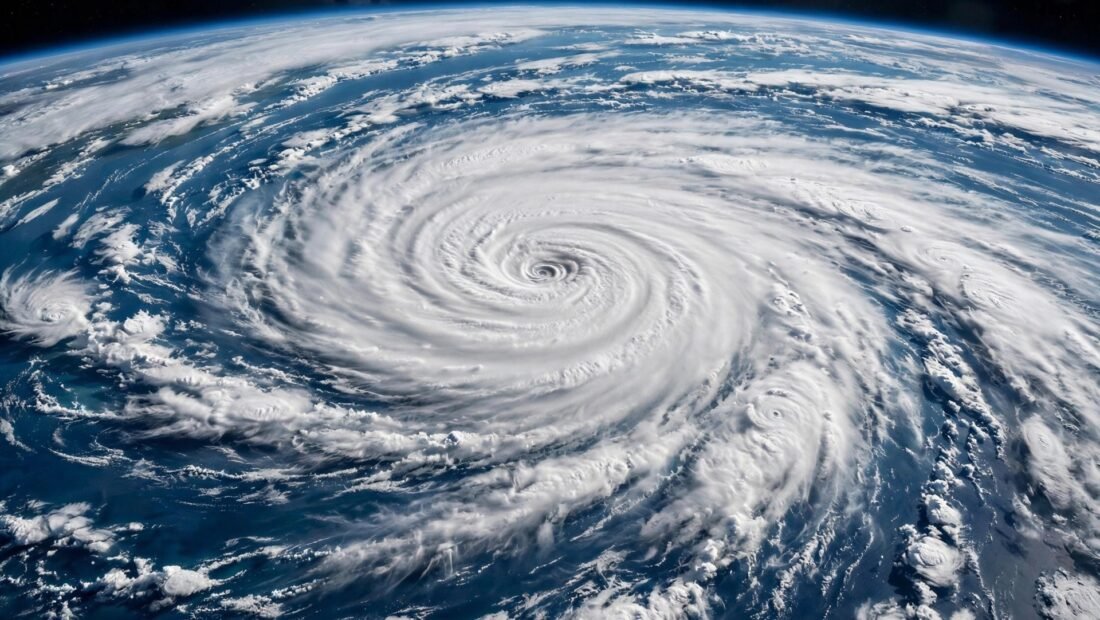
Cloud bands wrap into a spiral. Near the center a ring of towering storms forms the eyewall, where the fiercest winds and heaviest rain live. Inside that ring sits the eye, a calm column where air sinks gently and skies can clear for a short, eerie pause. On satellite images that clear eye is the sign of a mature, well organized storm.
The scale is hard to hold in the mind. A mature hurricane releases heat energy at a rate often compared to a 10-megaton bomb every 20 minutes. Only a small slice of that energy becomes wind. Most of it drives the vast lift of water vapor that later falls as rain. That split explains a fact that saves lives when people grasp it early: the rain and the sea do most of the killing, not the gusts.
Stage three: Intensification, including the rapid kind
Not every organized storm becomes a major hurricane. Intensification is the stage where a decent storm turns dangerous, sometimes in a single day. If the ocean stays deep and warm under the track, shear stays low, and moist air keeps feeding the core, the pressure can fall fast and the winds can climb with it.
Rapid intensification has a plain definition. A storm gains at least 35 miles per hour in top winds within 24 hours. Harvey did it before landfall. So did Laura and Ian in recent Gulf and Florida seasons. A storm that was a worry at breakfast can be a major hurricane by the next morning, which cuts the time people have to board windows, move cars, and leave low ground.
Forecasters have gotten much better at track forecasts over the past few decades. Intensity, and rapid intensity in particular, remains harder. A small shift in shear or a pocket of extra warm water under the path can change the outcome. That is why official cones show where the center might go, while the impacts, surge, rain, and tornadoes, spread well outside the cone line. Planning only for the line itself leaves a family exposed.
For deeper background as a season starts, the National Weather Service’s hurricane science and safety resources lay out how forecasters read these stages and what each watch and warning means in plain terms.
Stage four: Landfall, where water does the worst harm
When the storm reaches land, two things happen at once. The engine loses its fuel, because it is no longer over warm water, and friction with land roughens the winds. The storm begins to weaken. At the same moment, its danger to people often peaks.
Storm surge is the abnormal rise of seawater pushed ashore by the winds and low pressure. On a shallow coast like much of the Texas Gulf, surge can travel far inland. The 1900 Galveston storm, still the deadliest natural disaster in United States history, killed more than 8,000 people, most by surge. Today surge and inland flooding together account for roughly 90 percent of hurricane deaths. Wind damage wrecks roofs and power lines. Water ends lives and erases whole streets.
Inland flooding is the second half of this stage. A slow storm keeps its rain bands training over the same towns for hours. Harvey stalled and wrung itself out over Houston for days. Built up areas make it worse. Concrete and roofs shed water fast into bayous and streets that once were prairie able to soak it up. Flood maps, drawn from past records, can lag behind both new building and heavier rain. A house outside a mapped high risk zone is not a house that cannot flood.
Homes that take water need a calm sequence once it is safe to act. Knowing what to do if your basement floods after heavy rain helps, from cutting power to documenting damage before cleanup. In Texas many basements are rare, but garages, ground floors, and crawl spaces flood in the same spirit, and the first hours shape both safety and any insurance claim.
Why each stage now loads heavier than it used to
The stages have not changed. The conditions around them have. The oceans have absorbed about 90 percent of the excess heat trapped by warming, so the fuel in stage one is warmer and often deeper. A warmer atmosphere holds about 7 percent more moisture for each degree Celsius of warming, so stage two lifts air that carries more water, and stage four drops more of it as rain.
Research points to more storms reaching high categories, a rising share undergoing rapid intensification, and slower forward movement for some storms, which parks the rain longer over one place. Sea level rise adds a separate lift. Even a storm of the same strength pushes its surge onto higher seas than its twin would have fifty years ago. Along parts of the Gulf, land sinking from groundwater pumping adds to that local rise, especially around Houston.
One point needs care. The total number of storms each year may stay flat or even dip a little. Fewer storms can still mean worse storms. For a Texas family the count matters far less than whether the one storm that finds the upper coast this year arrives hotter, wetter, and faster growing than the storms their parents planned for.
The Texas readiness timeline that closes the loop
Preparation works best as its own timeline, finished before any storm has a name. Know your evacuation zone and your route out before an order comes. People who learn their zone during a storm lose hours they do not have. Keep 72 hours of water, food, medicine, and pet needs ready in the house, and a go bag with copies of key documents, chargers, cash, and a change of clothes in case you have to leave fast.
Sort insurance early. Standard homeowners cover in Texas does not include flood damage. Flood cover, through the national program or a private seller, has a waiting period in most cases, so buying it as a storm enters the Gulf is usually too late. Take photos of rooms and serial numbers now and store them outside the house in cloud storage.
When a storm threatens, work the last steps in order. Fuel the car. Move loose outdoor items inside. Fill tubs and containers with water. Charge phones and battery packs. Decide your leave trigger ahead of time, such as an evacuation order for your zone or water rising on your street, and honor it without debate at midnight. Most fatal choices in hurricanes come from waiting to see, then meeting water on the road.
Thoughts about stopping a storm at sea come up every season. Ideas range from pumping cold deep water to the surface to towing icebergs to seeding clouds. None has shown it can work at the size needed. You would have to cool hundreds of square miles of ocean by several degrees and keep it cool while the storm crosses, and shifting that heat and rain elsewhere could create fresh harm. The dreams are understandable. They are unproven, and they are no substitute for a house that is ready and a family willing to leave low ground in time.